The past few springs we’ve set aside a few days to paddle some of Minnesota’s Water Trails. This year our initial plan was for the Little Fork, but alas the snow melted quickly, swelling the river, and then drought brought water levels to solid medium. There’s lots of rapids on that river and we only wanted to paddle it at high water so enter plan B. Last year I’d thought about doing the Otter Tail but was quickly turned off by numerous low bridges, dams, culverts, and no campsites. It was obvious this was a minimally paddled river and not friendly for non-motorized boat traffic. This year though, water levels were still high on the Otter Tail at the end of May for our trip and the river was within reasonable driving distance for my mom to give us a ride and so we decided to go for it. I felt a lot of trepidation about all those culverts though.
The official map start to the Otter Tail is just east of Detroit Lakes off Hwy 29. From here the river mostly flows south (initially a bit east, then back west) before it turns and goes mostly west to the hamlet of Breckenridge, MN where it joins with the Bois de Sioux to become the Red River of the North. It is fairly unusual for two rivers to converge and the name of the larger to not be taken and instead a whole new name given. Apparently, back in the day, the entire Otter Tail used to be known as the Red River of the North and at some point the upper part got renamed to the Otter Tail.

We drove up to Bemidji, where my mom lives, on a Friday night and the next day, Saturday, she drove us to the start of the Otter Tail. As we drove, we straddled the continental divide, passing lakes called “Height of Land.” To our right, initially heading north, was the Mississippi Watershed that would end up south in the Gulf of Mexico. On our left, to the south, was the Otter Tail/Red River watershed that would eventually turn north and flow into Hudson Bay. Crazy.
Alas, we had five days to paddle. I always want to be as insanely efficient as possible so our goal was to paddle to Fargo. Cause what a destination that would be …. and I figured 260 miles in five days would be about our max and that would provide a reasonable return shuttle.
Water Levels
As noted above, when paddling just about any river, water levels are very important. We’ve usually found the sweet spot to be medium-high or high. We’ve hit too many rocks at medium or medium-low in the past. Levels reported below were high with a couple medium-high.
5/27/23 Otter Tail gauge at Elizabeth 862 cfs. Made for some exciting culverts but in general allowed us to run small dams as well as the rock weirs in Frazee. We only scraped twice on rocks.
5/28/23 Otter Tail gauge at Elizabeth 845 cfs. This may be the least important stretch of river for water levels given the swamps and a couple big lakes.
5/29/23 Otter Tail gauge at Elizabeth 830 cfs. Perfect conditions for running the gorge above Fergus Falls including the rapid just upstream of Broken Dam. Makes for a very exciting Class III+ at Hoot Lake dam/rapids. Too much flow to go through the I-94 culverts except in whitewater boat, yet this amount of flow was needed just below the I-94 culverts! Win some and loose some. Can’t have it all.
5/30/23 Below Orwell Dam 1200 cfs. Breckenridge 1290 cfs. Red River RR1 2410 cfs. This seemed about perfect for the section below Orwell Dam as well as going through Breckenridge and allowed us to take the diversion into the Red without hitting any riprap.
5/31/23 Red River RR1 2400 cfs. We suspect the Red can be run much lower than this. Because water levels had recently been higher, the banks were very muddy. Hence might be best to run this section either when water levels are rising or if they’ve been at steady state for awhile to allow the banks to dry out.
Day One 5/27/23: Otter Tail River mile 159 to 123

In addition to providing us a shuttle, my mom was also babysitting my niece (age 5) and nephew (age 19 months). My niece gladly took our offer to paddle the first two miles with us. Once we were all loaded into the canoe, we lined up to shoot the first culvert under Hwy 29. But the strong south wind had other plans as it blew us off course and we had to fight in the shallow water to re-align. I knew if at mile zero of this trip that we were already fighting the wind, it would be a long few days ahead of us.
The culvert was straightforward but afterwards we were treated to a narrow shallow stream with clear water. My niece got right to work, slowing us down by dragging her arm in the water but she was having a blast and kept asking, “Auntie Elspeth, where are all the fish?”


The official Minnesota DNR Water Trail map of the Otter Tail provided little info other than noting culverts and low bridges. It failed to mention much in the way of rapids or alternatives to culverts. So before the trip, I had scoured the entire river on Google Satellite. A little less than a mile into the river we came to our first rapid where the river narrowed. With such little water, it was more of a baby rapid and my niece loved it.


The river stayed fairly narrow and soon we approached the first bridge of 335th avenue where my mom was waiting to pick up my niece. The map said there might be a foot drop at that bridge but the water was smooth for us. Soon after was the Hwy 34 bridge. Just downstream on the left was a tubing take-out. Then just downstream of that was a big beaver dam. It must’ve been three feet high! We tried to shoot over it but got stuck and so had to get out of the canoe and pull it over.
In another mile we encountered a low private bridge (this was on the map). We had to portage this one and it seemed to take a long time as we had brought with a bunch of water which made the packs heavy and we had an extra plastic container to carry. Then we got back in the boat for another mile to the second Hwy 29 culvert. Per Google Satellite there appeared to be a wave coming out of this culvert but no note of any danger/obstruction was made on the map. We approached cautiously. Fortunately the river flowed straight through here and so even though where was a couple foot drop into the culvert and another couple foot drop out of the culvert, it was all smooth although we still managed to take on a bunch of water and surprised the fishermen on the downstream side. After the culvert (not quite immediately) the river turned right and seemed to be a bit flooded. Here we left the forest and entered our first swamp. We turned back and forth and back and forth and when we went south we battled the wind although it helped keep us cooler as temps got into the 80s.

After a few miles of swamp, we returned to the woods on what had already become a bigger stream. We stopped for our first lunch and then kept going. The Wannigan Road Access had lots of barbed wire fences and a gate like the map said and we were glad to be able to easily paddle under the bridge. Official map info: “Easy to pass under during most flow conditions. Difficult portage due to barbed wire fence connected to bridge on all four corners. Close gate behind you, and respect private property.” Soon we returned to more swamp. After a couple miles we saw a farm in the distance and we wandered towards the farm and then away from it and then back towards the far and away and towards until finally we passed it. In this section we saw a baby garter snake swimming across the river.

We were closing in on the small town of Frazee and the map noted some rock weirs. First we passed under the private covered bridge at mile 144.9 that was an old boxcar turned into a bridge without difficulty. We didn’t see any concrete or rebar at the old bridge site at 144.8. Next up was the North Lake Street bridge and the beginning of five man-made rock weirs. Fortunately water levels were good and by staying in the middle of the channel these were easy class I rapids and I think we only bumped on rocks once (because of course there were rocks in the middle of the river, too. Mile 143.5 “East Main Avenue Bridge. Depending upon flow conditions, experienced paddlers can make it through. Others should portage on either side.” No wonder I was so turned off from this river although we didn’t have any difficulty. Mile 143.3L “Two-foot diameter utility pipe across river. If river is low, possible to pass under by ducking. Otherwise, 30 yd. portage.” What the hell? Fortunately we were able to duck. Then there was was this at 143.2R: “Three bridge crossing consisting of two roads and one railroad bridge passing over the roads. No passage underneath first bridge. Portage on right along road. Watch for traffic!” Per my Google scouting I had seen a low road crossing at an angle. I couldn’t fully appreciate what was going on from Satellite but we soon saw.

Very low road bridge with train bridge on top! Erik and I didn’t want to portage so we laid down in the canoe (from our seats) and slowly made our way through the farthest left opening. My nose was about four inches from the ceiling. Good thing the current wasn’t very strong. Towards the end, because the bridge was at such an angle, it got all light on my right side but yet there was still concrete above my head which was kinda weird. Then almost immediately after we had another easy double culvert.
After a bit of swamp paddling we made it to the Frazee [rock] Dam. There was a legit park and portage here where we filled up on water and used some flush toilets and had second lunch. There was an info board up with the DNR map of the Otter Tail River and also a warning about the culvert under Hwy 10 that was coming up in about a mile but no specific info to help us navigate it.
Our map cautioned: “At River Miles 142.0, 134.0, and 116.0, the river passes through culverts under State Hwy #10. Paddling through these culverts is not recommended except by experienced paddlers. Be sure to scout them first for hazards such as high and /or fast water, drop offs, floating bogs, and other obstructions. DO NOT portage over Hwy #10.” Here we assumed that while we are experienced paddlers, thorough scouting would of course include crossing Hwy #10 to check out the culvert exit. Definitely not well thought out. And no alternative provided.
We got back in the canoe and paddled towards the first Hwy 10 culvert (there was just one). We made sure we could see it was fully unobstructed before proceeding but we did see some big waves at the end. This culvert was long and at the end we decided to shoot through the rock gate in the middle which was lucky as this turned out to be the least obstructed way through the rocks. Again we surprised some fishermen. We suppose a bunch of big rocks were dumped at the end of the culvert for erosion control but this creates a serious river hazard.
We spilled into a small pool and then paddled down a class I rapid with more small boulders that our canoe bumped on. The next few miles were largely marsh with a couple high banks and many turns. We spotted a beaver swimming underwater towards its lodge. The wind and small waves on Rice Lake made us really work for it and by the time we’d paddled the mile across it, my wrists were sore. From here we turned east and so had a few miles without the wind.
I’d scouted the series of three culverts coming up next under the service road, then a brief break before Hwy 10 again, and the train tracks. From Google Satellite I could tell that Hwy 10 had two culverts and then the train tracks three. I was glad I had scouted all this as we approached. The water wasn’t too crazy rushing through and we had just enough time between the last two culverts to re-align. Stupid.
By a couple miles later we were getting hungry and found some private land to cook our dinner. There was a small mowed patch here that led to a pole barn. We were glad no one bothered us. It was warm and Erik wasn’t having the hot dinner and put the pot in the river to cool it down. After dinner we got back in the canoe and snuck up on a beaver!
After a few miles of river paddling, we entered Mud Lake. It looked like from Satellite that there was a culvert or small opening where we might be able to take a shortcut into Little Pine Lake but when we got there, there was too much water for us to make it through the low culvert so we continued around in Mud Lake until we were able to take the channel into Little Pine Lake.
It was nearing dusk by the time we paddled onto Little Pine Lake, hence the wind had settled down some and we mostly had a cross wind anyway. It was relatively easy. We weren’t sure what the dam looked like on the far side of Little Pine Lake and slowly canoed under the road bridge. Next there was a ped bridge followed by a rock dam. Erik wanted to run it but I had some hesitation so I got out and portaged our gear around while Erik ran the drops.


Next we paddled the small marshy stream between the Pine Lakes. The water was still clear and I looked down to spot a snapper that looked to be sea turtle size. It was almost sunset and obvious by this time that we weren’t going to make our 50 mile paddling goal on the day so we looked for some place to camp. We found a spit of land with a deer trail that didn’t have too much poison ivy and we got to work setting up camp and crawled inside the tent with the last of daylight.

That night we were awoken by a fishing boat using a search light and another motor boat that annoyingly kept going up and down the channel, it’s motor making extra noise as it was kept mostly above the water to not get snagged on the weeds. This kept Erik up a long time (didn’t help that we were stealth camping and felt quite exposed with that search light) but I was mostly able to sleep through it.
Day one summary: headwind, lots of culverts, and small river.
Day Two 5/28/23: Otter Tail River mile 123 to 84.5

With lots of paddling to do to make up for the previous day, we got up shortly after daybreak which was before 6 am. After a quick breakfast, we got to paddling. The wind hadn’t picked up too much yet for Big Pine Lake. The channel to the river at the end was a bit hard to find as it was overgrown with weeds but we got in there without much difficulty. Erik kinda wanted to run the low-head dam but it looked like our stern would get stuck bad on the concrete so we did a short portage.
Just downstream of the dam we saw lots and lots of fish. We wound around a bit, saw a nice hill that would’ve made a great campsite, and then approached the Hwy 10 and railroad bridges. Our map said that there were three culverts for Hwy 10 but satellite told me reassuringly that the last one was a bridge and indeed it was.

After crossing under Hwy 10 we paddled south. The wind continued to beat on us as the river was still marshy. The miles slowly wore on and the late morning sun baked down on us. We went through some very off-angle culverts without strong current. I lost our place on the map and thought we were way farther ahead than we actually were. I wanted to wait until the far side of Rush Lake for first lunch but Erik was too hungry so we took a break a couple miles upstream of Rush Lake.

After first lunch we kept paddling into the headwind and after half an hour came onto Rush Lake. The wind thwarted our plan to head southwest towards the outlet. Instead we had to paddle directly south into the wind.. Neither Erik or I were wearing our life jackets because it was so hot but the wind created quite the chop on Rush Lake even though it was only three miles across. The bow on our Jensen 18 kept going under the waves and we were getting a ton of water in the canoe. I’d try to hold the bow up sometimes but more often than not, the bow still went under.
I began thinking about what we’d do if we tipped and made a plan that I had to get my life jacket on before I did anything else. There were a few motor boats on the lake, but even thought it was Memorial Day Weekend, there weren’t many, probably because the waves were so big. I was thinking that if one came to ask if we needed help, perhaps we should take them up on their offer.
About half way across Erik realized he had to bail out the canoe so he asked me to keep it pointed into the wind while he grabbed his water bottle to bail as fast as he could. But there were gallons in the canoe by then and his water bottle was less than a quart so soon we resumed paddling and he did another bail session after awhile.
I was paddling so hard that my wrists were killing me by the time we got to the far protected shore. By now we had to paddle almost an extra two miles to get to the outlet but at least we didn’t have to deal with the wind. There was another low-head dam at the end of this lake, too, and this one looked pretty easy to shoot so we did. We were ready for second lunch and stopped by the railroad bridge to eat and dump the rest of the water out of the canoe.
Next up was Otter Tail Lake, tenth biggest in the state. Fortunately this one was ever so oriented southwest to northeast AND had this crazy sandspit at the inlet that we were able to tuck behind to avoid the biggest waves.
But all good things must come to an end and eventually we ran out of sandspit and were in Otter Tail Lake proper. At least by now the shore was more protected and the waves manageable. It was broiling hot and Erik kept dunking his shirt. There were so many pleasure boats and people looking like they were having a lot more fun than us. It took us three hours to paddle the nine plus miles or so the long way across Otter Tail Lake. There was a big fire burning west of the lake. At the far end we stopped for a much needed extended break at the boat launch as we cooked dinner in the shade of the bridge.


Then we paddled on, Erik shooting the low-head dam first. He said the stern bumped the concrete on the back so I think I made the right decision by portaging around.


Next was a brief channel section with good current and then a series of lakes that also seemed to have good current. And we had a tailwind to boot! As we got back in the river, a pontoon boat pulled out in front of us. We started riding its wake and then passed it. Erik began griping at me for trying to make so many miles and paddling from dawn to dusk. I asked him what he’d like to do instead and he quickly replied “Stop and read all the signs!”
“That looks like fun!” a woman on her dock called to us. If she only knew we’d been at this for over 12 hours on the day, were still behind schedule, looking for a place to stealth camp away from the cows, and after all the effort were merely trying to get to a highly mocked town called Fargo.
After a few more bends we were approaching the Phelp’s Dam and Mill. It didn’t look like good camping and when Erik saw some cow pasture on the right that looked like it hadn’t been used yet this season, we decided that was the place to set up our tent and we’d have breakfast the next morning at Phelps Dam where Erik would have plenty of time to read all the signs.
Day two summary: headwind, big lakes, and low-head dams.
Day Three 5/29/23: Otter Tail River mile 84.5 to 38

As planned, we rose early, particularly early as we didn’t want the farmer to decide this was the day to let his cows out to this pasture, and we paddled less than a mile to the Phelps Dam and old mill.


So we had a leisurely breakfast and made use of the outhouse and drinking water before getting back on our way. Erik read all the signs:) We paddled a bit of stream, found the first lake we came to completely overgrown and just looked like more river, and then paddled across West Lost Lake.


After Lost Lake we paddled under a bridge and then were met with a northern forest view.

We paddled some more lake before we made it back into river for five miles before we got to Red River Lake which had some surprisingly big bluffs on either side. I failed to take a photo on this lake, largely because I was in such a hurry to get to lunch at the next dam, but it was a skinny lake with a bridge across in the middle.

After Red River Lake we had a mile to the Taplin Gorge Dam. This was our first of many big dams on the day. We portaged to the right of the diversion channel and when we got to the end walked around the grounds while eating our first lunch.


Once back on the river we enjoyed a couple miles of swift current before we came out to some open marshy areas and had to fight the south wind once again. Some clouds came up and it briefly sprinkled on us.
The Diversion Dam came up on us relatively quickly and meant a return to more wooded river and less wind effect. The Diversion Dam is so named because it’s where a large diversion channel was built that went all the way to Hoot Lake Dam and cut off about 10 miles of river. Back on the water the clouds kept us cooler and threatened rain but it only ever sprinkled. Mostly the scenery was wooded with scattered houses but a couple times we went by farm fields. There was a blown-up inset on our map from the Diversion to Hoot Lake Dams.


Then we entered the gorge about mile 54. Apparently there used to be a dam called Page that failed and took out several dams downstream. The current picked up and got swirly. Water levels were still high though so we had no trouble cutting through the old Page Dam but could still make out where it was. On Google Satellite the water levels must’ve been much lower because it looked like a bunch of small rapids. The maps says about this area “Caution! Underwater hazards! Class I rapids.” We cruised along until there was a bend we couldn’t quite see around and some bigger rapids. We quickly back-paddled and made it to shore and a trail at the Broken Down Dam Park. The rapid indeed curved around and lost about five feet in height but remarkably had almost no waves. Erik wanted to run it and I agreed, so I moved my seat back and we strapped everything into the canoe and while it was a bit thrilling, we didn’t even get any water in the canoe.
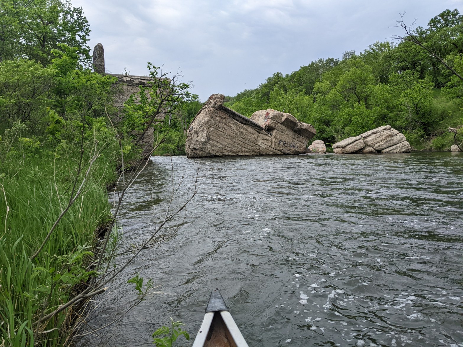
After another bend, we came upon the Broken Down Dam which on Google Satellite looked more like a European medieval remnant. We scouted and then went through the main chute.

Now we were closing in on the former Hoot Lake Dam for which the map said “Depending upon flow conditions, experienced paddlers can make it through. Others should portage on the left 240 yds. (difficult portage).” As we approached the dam, it was quite industrial with roads and bridges seemingly everywhere. The river was narrow and there were so many turns I was afraid we were going to shoot right over the dam. But the river does have signage and there was a warning portage sign followed by the real portage sign.
Other than the portage being a gravel wasteland, it looked like there had been recent upgrades to include stairs for both the take-out and put-in. Erik and I were hungry and there was intermittent cloud cover so we had second lunch although when the sun came out it was blazing hot. We scouted the rapid, at least a solid Class III, maybe IV at current water levels. Looked like it dropped about 10 vertical feet in 30 horizontal feet. We would’ve almost certainly swamped on the first wave and then it would be a couple more crushing drops. Even Erik didn’t want to run this one. I mean, we probably wouldn’t have died but I’d recommend wearing a helmet… so as for the “experienced paddlers” noted on the map, there you go. Google Satellite did this more justice than the map.
After the portage we put back in and wished the map had extended the inset to include the area through downtown Fergus Falls. Within a mile of the Hoot Lake Dam/rapids we paddled into a small lake. We turned left and ducked under an extremely low train bridge and then saw the take-out at a public dock. Just as the map said, we took out on river left on the pavered “River Walk.”
From here we walked along the river. There was a little ways before we got to the dam- another big one. The map warned “Paddling is not recommended from River Miles 49.0 to 48.3 because of dangerous obstructions.” The first one was almost immediately below the dam and was a large pipe crossing. Alas, we continued on the River Walk but the narrow river with good current was calling. We knew there might be some more submerged pipe crossings but we got in anyway but quickly had to bail within 100 meters as we saw such a pipe crossing that would’ve just about taken off our heads with a Class II rapid underneath.
Thus we returned to River Walk. At the end of the River Walk the retaining wall had fallen in and the stairs leading up to road level were technically closed. We carefully stepped around the retaining wall pieces, climbed the stairs, and then climbed over the gate.
Dear Fergus Falls: you try so hard (pavered path!!) and fail so spectacularly.


It was unclear from here where we were supposed to put back in (again, a detailed map would’ve been very useful) but Erik noticed a moderately steep dirt path heading back down to the river and suggested we take it and get in there. We did so and were cruising until we came to the trestle train bridge which was pretty log jammed up. We back-paddled and found a clear route through on the far left side. Train bridge behind us, we found flat water backed up behind the Pisgah Dam on the Otter Tail Reservoir.

We portaged left around the Pisgah Dam and noted all the water running The current was good and it was less than a mile to the I-94 culvert. When we came around the corner and saw the triple culvert, we immediately started back-paddling and went to shore to scout from the canoe. The river took a turn to the right to enter into the culvert. We could see that there was an initial wave heading into all the culverts and that each was free of obstruction. The wave was about a foot- not necessarily bigger than what we had already done. There were some waves on the far side of the culvert but these just looked like turbulence rather than more rapids. The map said “I-94 bridge. Caution: There is often debris obstructing culverts under I-94. Culvert on far left is best option. ” It’s also illegal to portage over I-94 and there was plenty of barbed wire fences preventing us from doing this anyway.
Despite what the map said, we decided to go through the middle culvert. Erik knew it would be difficult to line us up as the culverts were each narrow- about six feet across- and the current would be shoving us into the left concrete side. We put our life jackets on and headed towards the culvert. I presumably had a better view in the front and although we had scouted from 30 feet away, as we got closer I could see that the wave was off-camber. Then as we got even closer, I could see that there was a corkscrew wave on the right side of each culvert that seemed to drop three feet and took up nearly a third of the culvert. I looked back at Erik and probably muttered something like “Are you sure you got this” and he said yes but as soon as we hit that wave we tipped over.
If memory serves me right, this was the fourth time Erik and I have tipped together and one of those times we were purposely screwing around on Lake Ontario and working on deep water self rescue. Hence this was our third time tipping in a river. Although we haven’t tipped a lot, I think we both knew what to do- hold onto the paddle with one hand and the canoe with the other and just float through the culvert. Of course after the culvert we got tossed around a bit in some waves and then we began trying to make our way to shore to right the canoe and dump out the water and make sure we had all our stuff.
My foot brace, a piece of foam that had been duct tapped into the canoe, had come loose the day before and so mostly what I thought about as we floated through the culvert was whether I’d loose my foot brace and how much that would suck for paddling the next 145 miles to Fargo.
After the waves, somehow the canoe became more perpendicular to the river and began pushing me into a tree on the left shore. “There goes your foot brace,” Erik called to me. I let go of the canoe to collect the foot brace but then got tangled up in the tree. I’m gonna die over this stupid foot brace! I thought. Erik kept floating downstream with the canoe and eventually I got out of that tree but almost got hung up in another with our big orange pack. I grabbed the orange pack and shortly thereafter got to shore with Erik. It was a relatively steep bank so we couldn’t do a proper reconnaissance but he was eventually able to get most of the water out of the canoe and we noted that we had all of our stuff.
We got back to paddling on the twisty river, mostly past a bunch of houses. The Pelican Brook came in our our right, the largest tributary of the Otter Tail. I checked my phone and we made plans to take a break at the next bridge. Before we got there we paddled through some riffles and then it wasn’t a bridge but more culverts but these ones were easy enough- two big culverts and no turns on either side.
We took out on river right. Storm clouds threatened to pour rain but we set about spreading out our stuff and trying to dry it even though this wasn’t a good place to do so as it was all grassy and we had to avoid some poison ivy. Erik discovered I’d failed to close Ruby, our maroon pack, properly, thus the contents were wet including our extra battery and the peanut M&Ms. Then my phone started malfunctioning. It had been in my kangaroo pocket of my bug shirt instead of my life jacket where it would’ve been kept slightly more dry.
It tried raining on us a couple times and we had to consolidate our gear. Erik cooked dinner and we ate it but felt unsettled. We had gotten all wet but it was warm enough (in the 80s) that we didn’t need to worry about staying warm. I was more discombobulated as my phone wasn’t working.

Hindsight is always 20/20 and our map didn’t make note of any portage options around the I-94 culvert. It took me a month to pull up Google Maps and see there would’ve been a 1.8 mile road portage and this could’ve been deduced from our map as well. It would’ve covered four river miles for a culvert less than 0.1 miles in length. Had we known our chances of flipping in the culvert were so high, maybe we would’ve portaged. It’s also possible we may not have tipped had we taken the far left culvert (where there was a bit less current) AND had we gotten off our seats and kneeled in the canoe to get our center of gravity lower.
After dinner and eating some wet peanut M&Ms, we got back in the canoe to paddle our final section into the wind on Dayton Hollow Reservoir. This dried me off the rest of the way and before too long we arrived at Dayton Hollow Dam and Park. This was another big dam although the spillway appeared a little more gentle than some of the others. There was another beautiful old hydroelectric house and perhaps I would’ve taken a photo had my phone not been drenched.
There were some riffles and good current below the dam. We snuck up on a beaver onshore. Around a couple more bends there was a series of Class I rapids and a bunch of pelicans. Then the water calmed as we were already getting the back-up from the Orwell Dam. Soon we were nearing the Orwell Reservoir and Orwell Wildlife Management Area. It’s a bit unclear from the map, but per signs out on the reservoir, I believe there’s a small section where being onshore is not allowed. By now it was starting to get dark and Erik was thinking we should camp. He saw a grassy bank ahead and we went for it. We ended up climbing up the grassy bank, trying to avoid some poison ivy, and then camping on the edge of a planted corn field.
Day three summary: big dams, good current, and one nasty culvert.
Day Four 5/30/23: Otter Tail River mile 38 to Red River mile 545


Daybreak came early and after sleeping in a bit, we were back on the river by 7 am. The wind had died down some and we had peaceful canoeing out on the Orwell Reservoir.


As we approached the dam, there looked to be a park of sorts on our right that was not noted on the map. Instead the map told us to portage on the left. Erik was looking for a toilet but we didn’t see any and the put-in seemed to be almost obstructed by a fence. We may have technically put-in too soon as another quarter mile downstream we came to a park that had a minor put-in, a picnic table, vault toilets, and one big snapping turtle. This park wasn’t noted on our map either.

After using the vault toilets, we got back in the canoe and finally cruised without any headwind. The next stretch noted some rocks in low water but we didn’t have any problem and other than the heat and sun, we were finally making good time! We stopped under the Hwy #19 bridge at mile 23.3 for first lunch and stayed well out of the sun.

We did see the man made rock riffles, Class I at mile 20.1 and then not marked on the map but present was a solid Class I under the Hwy #169/290th Avenue bridge. Despite the fast current, all the miles and heat were taking their toll and we got loopy. It was pretty clear we weren’t going to make it to Fargo and so we discussed a contingency plan for my mom to pick us up farther upriver.
“She’ll like that” I said to Erik, “because she didn’t want to deal with the Fargo/Moorhead rush hour traffic at 6 pm.” Erik thought this was hilarious and soon I was laughing so hard I was doubled over and couldn’t even paddle. I was kinda hoping to wait for second lunch until we got to the Breckenridge Lake Dam/rapids but Erik was burning up so we stopped under the Hwy #14 bridge at mile 9.9. There was lots of unfancy graffiti under that bridge nicknamed “The Lion’s Den.”
Once back on the river the skies threatened rain and it got kinda cloudy. Perhaps due to such high water levels, there was no Breckenridge Lake and instead the current was pulling us towards a Class II rapid under the ped bridge. We debated shooting the rapid but I was hesitant. I agreed to go for it and then bailed at the last second which led to a somewhat dicey experience getting out of the canoe as the current pulled the canoe and Erik near the rapid. Once I got our gear out, Erik got low in the canoe to run the rapid himself. The portage was very short but the mosquitoes super thick on the far side, even with my bug shirt.

Erik ran the rapids but took on a bunch of water so per usual he said I made the right decision.
After the dam it was only 7.1 miles to the confluence with the Bois de Sioux River. We wanted these miles to hurry up and get done. We heard lots of thunder but kept paddling anyway. It was humid and sticky as we paddled bend after bend. We completely lost track of where we were but seemed to be near downtown Breckenridge. At one point we came upon a corner we couldn’t see around and thought it might be the dam at 1.2 miles so we steered around cautiously but it was just flatwater. There were a couple diversion channels, including a big one at 0.3 that went right into the Red but our map warned “during high flows, water overflows banks into Red River. Concrete riprap may damage watercraft. Stay left.” We planned to stay left and take a break when we got to Welles Memorial Park at the confluence with the Bois de Sioux but we got to a point where a small amount of water went left and the vast majority of the current went right and that’s what we did and then there was a big river coming in from our left and Erik said “Where are we?” I got out Erik’s phone and checked the satellite which showed us on the Red. It was the most anticlimactic end to a river we’ve ever had.


Since we were already past Welles Memorial Park, we decided to take our next break at the Kidder Dam which was only a couple more miles downstream. Thus we canoed past the golf course which is half in North Dakota and half in Minnesota with a small bridge over the river connecting the two. If I were a golfer that would surely be on my bucket list:) We got loopy again in the heat and the sun had come back out after sprinkling on us a little. We saw a bird in a tree that appeared to fall into the water.
“That bird failed flight school!” Erik declared which sent us into another fit of laughter. It turned out to be a cormorant and was really just diving for fish. At the Kidder Dam the take-out wasn’t super easy and came pretty close to the “spillway” although the dam was really just a set of waves, probably around Class III, maybe just Class II depending on the line. We needed a long break and so we spent two hours under the small picnic shelter, drinking cold water, cooking dinner, making plans for our pick-up, and I went for a short run at the campground, trying to stay all in the shade.
Then we got back on the Red River of the North and cruised 10 miles in less than two hours to the Brushvale Bridge/boat ramp (the bottom of it was quite muddy) and campsite, arriving around 8 pm. It was a bit cooler paddling in the evening but when we turned west the sun was in our eyes. There were a number of islands in this section which was a bit surprising and nice to see and made the river more interesting.

Finally we pulled a 50 mile day!!!


Day four summary: and now we’re cruising!
Day Five 5/31/23: Red River mile 545 to Red River mile 492

We were on the river by 7 am after eating cliff bars with a plan to have breakfast at Fort Abercrombie, some 13 mile down the river. The gnats were out in full force and bothered us even in the middle of the river. The current seemed to be slower than the night before and it took us over two hours to get to Fort Abercrombie. Fortunately there was a nice dock to get out on so we didn’t have to deal with the mud. The caretakers at Fort Abercrombie were quite nice and invited us inside to enjoy some air conditioning and gnat free time as well as flush toilets before we continued on our journey. They were proud that Fort Abercrombie is on the North Country Trail and said a number of folks pass through there on that trail every year. They were also quite Eurocentric. There were some old relics around in a field but there was no shade and even though it was only 9 am the sun was beating down and it was hot so we got back in the canoe without seeing the relics up close.
This quickly became one of the most boring days of paddling ever that was only punctuated by literally two brick silos (failed to take a photo) and one red barn that made a face in 11 hours. The riverbanks were largely dense foliage of trees, shrubs, ivy, woodbine, and occasional pink wild phlox. There were lots and lots of turns, infrequent views of farms, and no interesting wildlife. The river water had varying densities of muddy swirls. By mid-day the gnats were less bothersome.


We had plans to stop in the small hamlet of Wolverton but there was no river access so we kept going to the next bridge which was very muddy and the expansion joints were ridiculously loud every time a vehicle drove over. After our tortilla lunch, we got back in the canoe for our last pull to the Minnesota County 2 bridge, just west of the Minnesota town of Comstock, where my mom was to pick us up at 6 pm.
5.5 miles later we came to the “Christine” rock dam with no official portage. We portaged on the left, trying to stay just above the rocks, without too much difficulty. It would’ve been run-able in a whitewater canoe, kayak, or packraft. Then it started to rain hard.
Usually when it starts to rain I get upset and want to stay as dry as possible but seeing as this was our last day on the river, it was hot, and we’d be picked up in a couple hours, I didn’t care so much.

After it rained hard for 10 minutes with thunder, the rain eased up and we were just starting to get dry when the sky opened up and it poured again, about an hour before our pick-up time. There was more thunder but we kept paddling and within another 10 minutes it was done raining.

Just a tad before 6 pm we canoed under the Minnesota County 2 bridge, looking for the least muddy spot to take out. By the time we’d battled a short section of mud and climbed up a gully on the northeast side of the bridge where my mom was waiting, we were five minutes late. Not bad for paddling 53 miles to cut the time that close. My mom said she had driven through quite the thunderstorms with straight-line winds. Apparently down in the river we were sheltered from all the wind.

Given the muddy banks, neither Erik or I are terribly excited to start from this spot again and we’ve already discussed belaying ourselves, canoe, and gear off the bridge to keep from getting so muddy when we resume the Red.
We were very grateful to my mom to come “rescue” us from the monotonous Red. Perhaps we’d just spent too many days canoeing in a row and that combined with the gnats and warm humid air were too much, but even with all the twists and turns, this river was boring!
Day five summary: why?
Canoeing the Otter Tail River made me really question my plan to paddle all of Minnesota’s Water Trails. Not that I haven’t questioned this goal multiple times in the past as we spend exorbitant amounts of time shuttling and driving in this quest. But the unfriendly culverts of this river validated my trepidation. In some respects, tipping under I-94 greatly contributed to the adventure but I could have done without soaking my phone as this created quite the distraction over the next couple weeks. Or maybe I should re-frame this to express my frustration by our reliance on technology as a society.
I’ve thought about whether this trip was worth my time. The conclusion I’ve come to is that paddling Minnesota’s Water Trails feels like moving through the back door of the state. Most of the Otter Tail had such clear water we saw so many fishes, turtles, and beavers. There’s something really special about being somewhere that few people get to experience even though it’s relatively close to society. And when I cross over rivers on roads, I always think about being down there, on the water, paddling.
I’ve also thought about how unfriendly the Otter Tail is to paddlers with all the culverts and a couple dicey pipe crossings. When I was kid we had a cabin on the Rum River in Onamia, MN. There was a sketchy trestle-style railroad bridge that was always so difficult to paddle through. It was in this era that Hwy 169 got its upgrade from a two lane to a divided four lane. While my dad lamented creating such a super highway for car traffic, ironically culverts on the Rum were replaced by high bridges making the river that much more accessible to paddlers.
The character of the Otter Tail vastly changes throughout its course. At only 160 miles it was like a microcosm of a larger river. There were narrow wooded sections, lakes, swamps, big and small dams, farmland, and that big gorge in the Fergus Falls area.
The Red [River of the North] was much different- muddy water and wooded banks that wound on endlessly for the first 65 miles. It was much more monotonous in comparison but should we keep paddling it, perhaps we’ll find some surprises.
So in the end, the trip was worth it. I’ll never think the same about the Otter Tail when I speed over the I-94 culvert or about that gorge in Fergus Falls. It feels a bit like we learned a secret about this part of the state that few others know but I do hope this inspires others to get out there and paddle and enjoy nature.

4 thoughts on “Canoeing the Otter Tail River and the First Map of the Red”