In pursuit of the Minnesota Water Trails, initially Erik and I planned to canoe the Red Lake River to the Red River to the Canadian Border with my mom providing a shuttle. Mother Nature had other plans with the flooded Red River creating what looked like a giant lake between Grand Forks north to the Canadian Border on live satellite. The water gauge in Drayton, North Dakota consistently registered at 42 feet, 24 feet above flood stage.
So we reverted to Plan B, the Ottertail River to the Red River and then north (downstream) to the Fargo area. But as I read the Paddling Minnesota guidebook and poured over the Minnesota Department of Natural Resources map of the heavily dammed Ottertail River with low bridges, scary culverts which warned to neither go through or portage over, and no designated water campsites, my interest waned.
If I could only paddle one more Minnesota river, it would most definitely NOT be the Ottertail. So we looked farther north and I pulled out the map of the Big Fork– 171 miles of twisting un-dammed river with a largely undeveloped shore AND designated water campsites. Plus, it would be a significantly shorter shuttle for my mom. This was our river.

The Big Fork water trail starts at Dora Lake, north of Lake Winnie, smack dab in the middle of the northern part of state. From there it flows mostly north through the towns of Bigfork and Big Falls before flowing into the Rainy River. To get in a little longer paddle and to make the shuttle more efficient, Erik and I paddled 7 miles up the Rainy River to the confluence with the Little Fork River, and then 21 miles up the Little Fork River to the town of Littlefork. Water levels were all reading “very high.” We surely wouldn’t have a lack of water- and perhaps too much- with the Rainy River being quite swollen.
Day One 5/22/22: Dora Lake to Busticogan Campsite- 48 miles
[Water gauge at Hwy 14 at 1100 cfs- very high]

Under cloudy skies, we paddled north on Dora Lake toward the outlet of the Big Fork River. My mom visited the Lost 40, an area of tall pines that weren’t initially logged due to a mapping error, before she drove back to her home in Bemidji with plans to pick us up five days later.


The initial 13 miles of the Big Fork went through a big swamp until the Harrison Boat Launch on Hwy 14. We saw a couple eagles and pairs of swans. There wasn’t much current and so after nearly three hours, we took our first break at the Harrison Boat Launch. Our map shows a campground there. While there was a picnic table, the privies were overgrown.

After a “first lunch” of peanut butter tortillas and dried fruit, we kept paddling. Now the river banks came together close as we left the marsh behind but we found the river surprisingly wide. Both Robb’s and the Hauck Rapids were washed out in the high water. We could see some little swirls and there were a couple rocks to avoid but no real rapids. The time slowly went by as I kept track of where we were on the map. My wrists were already hurting despite having done several 30 plus mile training days. What was going on? We still had so many miles to go. I couldn’t bail already.


We stopped for “second lunch”- a menu repeat of first lunch, at the Hwy 14 access. While we ate, we walked around the carry-in parking lot. When we got back in the canoe, I decided to not track the map and instead just watched the trees go by. This worked well as we were paddling by Bigfork before I knew it.
Our trip was 171 miles downstream and 28 upstream- so just about 200 miles which we planned to do in five days; however, we wanted to bank some extra miles while heading downstream so we aimed for the Busticogan Campsite with intention to stop at the Rice Rapids Campsite to make and eat dinner.
Given that the Rice Rapids Campsite was only four miles downstream of the town of Bigfork, we didn’t stop in town and kept paddling. Our map said the Rice Rapids washed out in high water, and since it was high water, we assumed they would be washed out. We were wrong. They were still a solid Class I, but adding to their difficulty the river split on the right bank, where the campsite is located. We skipped the first right channel but after going around a couple rocks, saw a sign pointing towards the campsite on the far right shore, right of the islands.
We had to quickly back paddle to go through the channel which was largely obstructed by down trees and our initial angle wasn’t tight enough so we had to back paddle again and re-approach. We made it through the trees and then the current from the right channel was so strong we had to eddy out just below the campsite to get there. This certainly wasn’t novice canoeing.
Once we got to the campsite, we unloaded our food and cooking gear and dumped out the water we’d taken on in the upper Rice Rapids. We don’t exactly equate getting water in the boat with Class I rapids. It took us an hour to cook and eat dinner and then we were on our way to continue the Rice Rapids. We had scouted our next line from the campsite. Again, there was a right channel that looked like it might just have enough water but could be a disaster if there were any strainers so we stuck to the main channel. As we approached, Erik decided we should back-ferry and hit the drop on the far right side where the waves were smallest. This worked incredibly well and we didn’t get any water in the boat- although is back-ferrying a Class I skill?
After the Rice Rapids the water again turned placid for a few more miles.


We kept paddling, past Sasquatch, and then shortly thereafter heard some rustling on the right shore. One bear high tailed it into the woods and another climbed a tree next to the river quick as lightening. We marveled at our luck seeing this bear, and getting a good view for so long. As we floated past, it scurried even higher.


There was another set of Class I rapids just above the Hwy 1 bridge and a mile upstream of our intended campsite. The map didn’t say much about these other than marking them in red whereas the Rice Rapids had just been in standard black. Ufffda- the river narrowed and dropped noticeably through this stretch. The rapids were relatively short as we stayed on the left but the waves were choppy and we got in a bunch of water. They definitely got my heart pounding, especially seeing all the water rushing into the bridge pier.
We calmed down in the mile of flatwater to the Busticogan Campsite- a picnic table near the river essentially in a field. There was an old broken down privy and a newer one Erik visited in the morning. It was nearly 9 pm by the time we got to camp so we set up the tent and brushed our teeth with the remainder of daylight.
The day had only been in the 50s but once the sun set the temps really plummeted. I didn’t wear my down jacket to bed and woke up cold in the middle of the night. Finally I put it on and buried my head under the covers.
Day Two 5/23/22: Busticogan Campsite to Easy Half Campsite- 41 miles
[Water gauge at Hwy 6 9.9 ft- very high]

It was 7 am by the time we woke and the sun was already high in the sky warming us up. We waited a bit longer to get up and by the time we finally got to paddling it was 8:39 am! So pathetically late.
Our first big landmark of the day was the Muldoon Rapids, marked as a Class II with 2-foot high waves reportedly at high water. After finding the previous day’s Class I rapids everywhere from nonexistant to challenging, we figured we’d likely portage the Muldoon Rapids but weren’t sure. There was a Class I rapids marked above the Muldoon Rapids but we never saw them. As we approached the first drop on the Muldoon Rapids, Erik said he didn’t want to portage (there was a portage trail with a campsite off the trail) and wanted to run them instead. He stood to get a better view. We discussed our route and at the last minute hit the main drop and decided to try to go left of the big wave train.
I really suck at drawing in big rapids and couldn’t get us left fast enough and so we had to take the big waves. We paddle a Wenonah Jensen 18. It has short side walls, no rocker, and is make of kevlar. It’s not designed for rapids- it’s meant to go fast on flatwater. So when we hit those waves the bow went under twice in succession. I used to really freak out when the boat did this- like in the vertical walls of the Erie Canal after a motor boat left a big wake or on the south side of Manhattan in the ferry wake- but now I’m more used to it.
After the initial drop there was a section of Class I rapids with a few rocks that were easily avoidable and then there was a second drop where we back-ferried and hit the rapid on the right and avoided getting water in over the sidewalls. While we had some water in the boat, it wasn’t enough that we needed to stop to bail so we kept paddling.
Rapid rating is incredibly subjective. I give a I to anything that really can’t be screwed up. I’d call the Muldoon Rapids an easy II.

As we kept paddling, we came up on a slow moving canoe with two guys. The bow guy was paddling a bit, the stern paddler never. Wow, a canoe! Erik and I joke that we can literally tell someone every time we’ve encountered another canoe on every river we’ve paddled in Minnesota because it’s so rare. Briefly we stopped paddling to talk to these guys. They had started paddling the previous day in the town of Bigfork and were heading to Rainy River over eight days. We told them we’d be at the Rainy River the day after next. They seemed shocked.


At Little American Falls we took first lunch. The “falls” is a six foot drop that according to our map is a IV-V. I have no idea who comes up with these ratings. True, it’s a bit of a tricky drop with no clear line (Erik and I came up with three potentials) but we didn’t see any holes, it’s one sole drop, and it wouldn’t be a long swim. I’d give it 3+/4-.


My feet were cold and so as I ate my tortilla I quickly walked the 66 yard portage several times which included a small hill at both the beginning and end. Around the time my feet got warm we got back in the canoe and paddled through the fast water at the bottom of the rapid.

Even though the forecast hadn’t called for rain, some dark clouds blew over and shed a few drops. We continued our paddle, the river twisted and turned. We passed many ferns onshore and thought about stopping to eat some “fiddle heads”- the name for the budding ferns. Eventually we stopped.

After a couple hours we came upon Powell’s Rapid which was a brief riffle, much less than that marked on our map. There was a tall house up on the bank. Another Class I rapid was marked on our map just above the Hwy 6 bridge but was completely washed out in the high water. We stopped for second lunch at the Hwy 6 bridge put-in and again walked around the parking lot. Our stomachs felt slightly unsettled after eating all those fern heads but the peanut butter tortillas seemed to quiet them down. After some debate about whether we should go for the close campsite in only another 10 miles or push on another 13 miles beyond that, we decided to go for the close campsite.
The next few miles passed without anything notable other than an almost constant cacophony of beavers jumping into the water from land and making giant splashes before we could even spot them. It was rare a beaver was caught so off-guard we saw them before they could belly flop. We began looking for the campsite on our left well ahead of the marked turn but we didn’t see it. Erik consulted the Avenzia map on his phone and said we had passed it. While the current carried us farther downstream as we floated and debated whether to go back, I said we shouldn’t backtrack as we hadn’t seen anything obvious. Erik lamented that he really appreciated the picnic tables. Alas, we continued on, our eyes peeled for a good camping spot and then as a small stream came in on our left Erik spotted a picnic table. The landing wasn’t great but we made our way out of our canoe and to the Easy Half Campsite, about a quarter mile downstream (farther east) of where it was located on the map, just east of the stream that comes in there with some descent topography.

Erik scouted around and found a four-wheel trail heading north from the campsite. He also found a latrine that appeared to have been drug in from somewhere. The picnic table was not level and the fire pit appeared to have been moved recently. Erik had a theory that either some four-wheelers moved the campsite or the DNR did so.


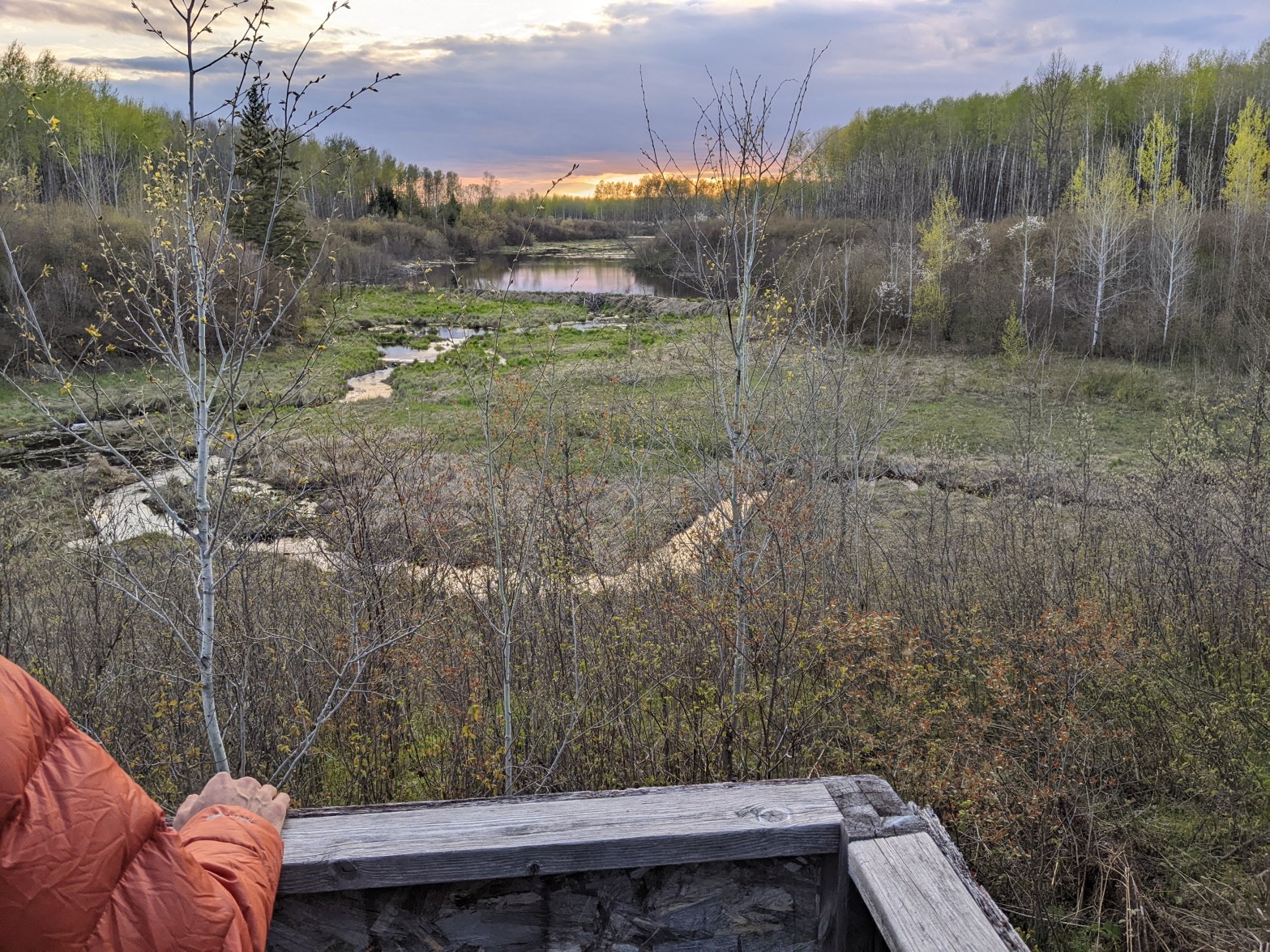
After we set up the tent, cooked and ate dinner, we went exploring on the four-wheel trail. We love water campsites that have some good trail/road for an evening walk, although prefer something more secluded that can’t actually be accessed easily from land. Not too far down the trail, we found it obstructed by two recently downed trees by beavers! This meant our tent, at the end of the four-wheeler trail, was unlikely to get run over by any rogue drivers in the night. To our left was a small stream down in a valley. As we proceeded, we came to a mini clearing. We walked that way and found a broken-down deer stand that we climbed into.

Before us was one of the most picturesque sites I’ve ever seem in Minnesota. It reminded me more of a small alpine valley with tiny streams heading downhill fast, only the beavers had constructed a giant lake due west of us and we could see them swimming in their pond and scurrying about on their dam. We were too far away for them to be startled by us.


We ambled on a bit farther and then turned around near 9 pm when we knew it would be getting dark soon. We slept well that night.
Day Three 5/24/22: Easy Half Campsite to Keuffner’s Landing- 51 miles
[Water gauge at Big Falls 6.2 ft- very high]

We woke earlier this morning and got out of camp just after 7 am as we knew we had miles to make. The paddling passed by quickly enough and soon we were paddling back under the Hwy 6 bridge and nearing the Johnson landing and campsite. I had quite the thrill there as I needed to use the “privy” (aka outhouse). The door was open and as I was about to enter, a songbird flew out. I screamed of course, realized it was a songbird, and headed back in but there was some noise so I was hesitant. I went around the side of the privy to kick on the wall. Only after I kicked did I realize there was a dead skunk, it’s odor still characteristically pungent. Eventually I got my business done, looking at the dead skunk through a large opening between the foundation and siding and listening to the weird noise (bird babies or a tree on the roof) but not before the songbird scared me a second time.

After the Johnson landing/campsite several more miles passed without anything exciting until we got to Grand Falls at the town of Big Falls. I’m not sure I would call this a falls but rather a long rapids with a series of multiple drops, many with poor lines, and a “box” near the end. The map calls this a IV but at the water levels we saw, I might give it a V, especially if one were to hit the more left line. There were a couple good sized holes and enough turbulence that made me dizzy just watching. We portaged to the left, a decent ways above the falls at the boat landing (we could’ve paddled closer to the horse campground just downstream of the old railroad bridge), crossed the river on Hwy 71, and then portaged down the boat access road on the right side.


We ate second lunch while watching the water explode off and onto rocks. Then we put in and kept paddling because we still had many more miles to go. There were some almost continuous riffles for a couple miles. Then the Sturgeon River came in on our left with a strong current. We looked upstream and could see a Class II rapid. Erik said we should packraft that river some time.
I didn’t pay attention to the turns and soon we were passing the Ben Lynn Landing. Erik wanted to stop so we did. Here the bank was high above the river but there were too many trees for a good view. Back in the canoe the shore passed by as the afternoon wore on. We never saw the Class I rapids marked at Mile 40. Then Erik spotted a wolf on shore and whispered to me.
The wolf was relatively light in color- an almost whitish gray-tan. We locked eyes, it trotted a few feet into the small shrubs by shore, looked back at us, trotted higher, looked at us again, and then disappeared into the forest. All the other animals we saw darted away so quick we only heard most of the them but the wolf lingered longer- a benefit to being top of the food chain.
Around the next bend I caught the rump of a bear as it high-tailed it into the forest. It was in a small gully and gone by the time Erik, in the stern, paddled by. Then we saw five otters playing on shore. Once they got wind of us they dove into the water only to re-emerge in perfect synchrony and start hissing at us before disappearing one more time.
As we neared Keuffner’s Landing, our planned campsite for the day, I followed the map much more closely. Usually Erik and I prefer campsites without road access but this one had a road and two women parked when we arrived. They seemed quite surprised to see us. It was the 5 o’clock hour and so we cooked and ate dinner at a giant picnic table. The women left and we set up our tent before embarking on an evening stroll down the road which climbed a decent ways. It was dusk when we made it back.


Day Four 5/25/22: Keuffner’s Landing on the Big Fork, to the Rainy River, up the Rainy River and then Little Fork to Mile 3- 40 miles (7 upstream)
[Water gauge at Manitou Rapids on Rainy River 50,000 cfs- average 16,000]

The day again dawned sunny. We lay in the tent listening to the wolves howl before getting up. After breakfast we started paddling. I watched the map as we gradually did bigger and bigger turns. Just upstream of the bridge at the cluster of houses marked as Landford on our map, we saw a strange animal. It almost looked like a white miniature horse but as we got closer we saw it was two pelicans.

After Landford I stopped following the map as the curves were simply too big. A couple corners later we stopped for first lunch. Then I lost track of where we were until we passed the Ivan Crawford Landing. A couple turns later a fast motor boat was blazing towards us. Fortunately they slowed and moved over for us but that initial wake coming off the boat always looks so scary.
We passed a few islands and about 3 miles from the Rainy the current slowed and we again entered a flooded forest. Knowing the Rainy was high, we could only assume the water was backed up the Big Fork. The sky got cloudy and threatened rain.


At the Hwy 11 bridge we got out in search of the Grand Mounds Historical Interpretive Center marked on our map. We found the building but it appeared to be indefinitely closed without so much as a sign. By now it was sprinkling so we had second lunch under the bridge. Expecting strong current on the Rainy, we fueled up, drank up, and got on our rain paints before continuing.


In 2014 on our Border Route canoe trip we’d paddled up the Rainy River but this time, with the water at least ten feet higher, it looked much different. We passed our previous campsite at the confluence of the Big Fork and Rainy, now several feet underwater. The last time we paddled this way, we didn’t see any of the Grand Mounds but this time, riding at the level of the bank, we saw three.

Initially the current was quite strong and we shed our life jackets. After an hour we reached the first big curve and the current decreased as the forest was flooded. We couldn’t help but paddle through some of the flooded forest. But all good things must come to an end and as we emerged from the forest the current took us hard until we had ferried all the way over to the Canadian shore.


Erik and I each touched a Canadian maple leaf and after the next bend we made our way back to the American shore. The current really picked up before the confluence with the Little Fork and we paddled hard. We had thought about camping at the island there but it was flooded, although easily visible as there are some really tall trees. Thus we began paddling up the Little Fork. Seeing as it was cloudy, barely 60 degrees, and quite windy, I was really cold. We again stopped briefly at the Hwy 11 bridge, this time on the Little Fork, and scouted a potential camping place 3 miles upstream that was as far as we could get from roads or houses per the satellite.


Erik’s satellite scoping proved good. On the outside bend there was a bit of a bank and we camped at the top on the edge of a marsh, definitely safe should the dam in International Falls suddenly break loose from the flood waters. The site certainly wasn’t ideal and we had to hide from a four-wheeler after dinner. But it got the job done and we’ve camped worse places.


Day Five 5/26/22: Little Fork River Mile 3 to the town of Littlefork- 18 miles upstream
[Water gauge at Little Fork 2500 cfs- very high]

Expecting the current to pick up, we figured we’d average 3 miles per hour so we woke early as to go undetected and get a good start as my mom was scheduled to pick us up at 4 pm. Instead we found more slack water and moved faster than 4 miles per hour until Mile 18 or so where the banks finally got steeper and the river narrower. Thus by 1:15 pm, with just one stop, we arrived at Logan Memorial Park in Littlefork. We had called my mom along the way and she was there to pick us up at 2 pm. Then we drove back to Bemidji, stopping at Great Falls along the way to be mesmerized by all the water again.


We didn’t paddle the Big Fork for the wildlife, but we certainly were spoiled by its sightings- bald eagles, swans, otters, bears, pelicans, a wolf, and a godzillion beavers. Seeing a wolf up close has been on my bucket list for a long time. Sure, I saw a black one in Glacier National Park but that was from a very long ways away and we may have seen one last year on the road by Bemidji, but we just weren’t certain it wasn’t a runaway dog. Now if I can see a lynx!
I prefer the scenery of the mountains as I remarked to Erik that much of the Big Fork was pretty boring. It’s a good metaphor for life- most of it is rather mundane and then punctuated by these extraordinary moments- like seeing a bear run up a tree or a wolf. And then there was that special little beaver stream by the Easy Half campsite.
As we paddled in preparation for our trip, we paddled many new waterways. Sometimes the miles ticked by slowly, other times quite fast as Erik, Garmin watch around his wrist, quipped on the lower Snake “we just did an 8:30 mile!” Sometimes I wonder why I continue in seek of these new waterways. We were quite surprised on the lower Cottonwood this spring with it’s giant sandy banks. “You don’t know unless you go” has previously been my moto and it’s resurfaced yet again on the Big Fork. What it lacked in scenery it certainly made up for in wildlife.


An enjoyable read as always. I share your ‘`don’t go / don’t know” aphorism. We have a friend in Minnesota, and now maybe we know a bit more about where he lives without going!
LikeLike
Exactly! Thanks for reading.
LikeLike