After our spring paddling trip, Erik desired something more chill so I came up with this 56 mile loop to do in six days in the eastern Uintas of Utah. The primary inspiration of the trip was to bag Utah’s highest point, Kings Peak. We started and ended at the Hoop Lake Trailhead which had trails running in two directions to make a loop and was about as minimally far out of our way as we could drive.

Day One 8/14/23: Hoop Lake to Long Meadow (out of Middle Beaver)

Given that we didn’t start until 10:45 am, I only had ten miles planned. We started from Hoop Lake on the Burnt Ridge Trail. Even though it was Monday, perhaps the empty national forest campground should’ve given us a clue as to the upcoming trail conditions.
We started under sunshine and breathed in the forest smells — clover in the low meadows and then pine scent as we climbed higher into the forest. The trail to the cut-off with the Thompson Peak Trail was well maintained and climbed at a steady but gentle enough grade. A trio on horseback passed us early on and then we didn’t see anyone again until we were in camp.


Once we got to the split with the Thompson Peak Trail, we were in a meadow and immediately lost the trail. We had Gaia maps on our phone but even using this we had trouble finding the trail. As we gained elevation and got in the woods again we kept seeing trail fragments but these didn’t last very long. Soon we had climbed above treeline and were skirting the side of Thompson Peak. We didn’t see any evidence of trail and so we continued, mostly on grass with rare boulderfields, on the north slope of Thompson Peak.


As the “trail” headed back into the forest we tried harder to find it. Even with Gaia we would stumble onto it for a bit and then loose it and try to regain it. This kept on as we descended to the valley and held true even after merging with the North Slope of the Highline Trail. It wasn’t until the trail to Beaver Lake finally came in that we had a trail that was easy to follow.
Not long after we got to the Long Meadow. We hiked across this, crossed the creek on a large down log, and then found a well established camping area (appeared popular with horse campers given the large amount of horse poop). Seeing as it was 5 pm and we’d gone our planned ten miles, we established our own camp.


There were more mosquitoes and flies than I like and it was fairly warm. Dead wood was plentiful and there was a nice fire pit so Erik got us a fire going, our second in only a year after so many years of never having campfires.

Day Two 8/15/23: Long Meadow to Kitchen Rock Campsite via the North Slope of the Highline and then Henry’s Fork Trail

We woke to more blue sky but given the previous day’s difficulty finding the trail, I suspected we were in for many hours of hiking around in the woods, often going up and over down trees, in search of the trail. Indeed, our difficulty began immediately as the trail leaving camp towards the west was essentially obsolete. We made our way to a cairn in the meadow, but no luck there either. After searching and essentially just walking around in the woods in the direction we were going, we hit trail remnants that often lasted 10-50 meters before ending in a pile of down trees. I expected this now and expectation is everything.


The trail didn’t get any better after we crossed the West Fork of the Beaver Trail except for just before we got up on the plateau where the trail climbed steeply. Once on the plateau we found a large meadow and were able to follow a series of cairns. We rustled up a couple elk and then found a very large sheep herd near the western end.


As we began dropping into the next valley where Joulious Creek flows, we took our second lunch break on a rocky outcropping and then lost the trail again. Finally, after we crossed the creek we had some easier time finding the trail again. But then we went across a big meadow and had trouble finding it again. It was 2:45 pm now and the first of the thunderstorms rolled in. We headed down a very steep pitch into the Henry’s Fork area but then lost the trail again and were literally relying on orange ribbons tied to trees as the rain began falling on us.


Finally we made it to the Henry’s Fork main trail and it was like a super highway. After Erik crossed for the fun of it on the off-camber bridge at Elkhorn Crossing, we spent the next hour hiking gradually up towards Dollar Lake and never once lost the trail. It mostly stopped raining. A couple groups of hikers were heading down valley and warned us of a moose and her calf near the trail at a stream crossing but we never saw them.

Even though it was raining, the views from the Henry’s Fork Trail and valley were obviously impressive — way better than we’d been hiking through so far.

We had intentions of camping at Dollar Lake but never saw any social trails heading that way. Erik was developing some GI upset and when we saw an obvious campsite from the trail (later we’d see on Google Maps that it was called “Kitchen Rock”) we took it. It was 5:30 pm and we’d been going for ten hours, even though it was only 12 miles on the day.
By now it had stopped raining, but I had my poncho on to try to dry it out but seeing as it didn’t have any arm holes, I soon learned it was completely useless in camp. We got the tent set up and then began making dinner but the ground was all wet and between Erik’s GI illness, finding water, me learning my heel blister bandage had failed (on day two of thirteen), Erik burned his fingers making dinner, and seeing as we planned to climb Kings Peak the next day, we were quite discombobulated.
Eventually we got everything sorted out. I headed down to the small pond to clean my face and brush my teeth before dinner and enjoyed the alpen glow up on the mountains although I didn’t quite get a photo.


Day Three 8/16/23: Kitchen Rock Campsite, up Kings Peak, and down to Painter Basin

Erik didn’t want to set an alarm but I figured with early afternoon thunderstorms expected, we needed to summit Kings Peak by 11 am. We woke with dawn around 6 am and heard a party already heading up the mountain and saw a second one while we were still in camp. We were on the trail by 7 am and I led with a brisk pace.
Again the trail was easy to follow and very gradual owing to a large switchback to Gunsight Pass where we broke into the sunshine and didn’t linger long. Leaving Gunsight Pass we caught a social trail that skirted around the east and then south side of Dome Peak. Initially the trail was amazing but then it petered out as we got to a steeper section where we had to use our hands some. Once we got up on the flatter section we were able to hike on grass for awhile but then we got into some boulders and Erik suggested we head down a bit into the basin to find the trail, which we did.


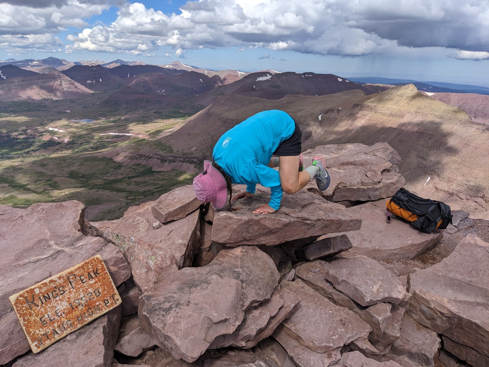
From there we had a brief hike up to Anderson Pass where Erik suggested we stash a pack before continuing the final 1,000 vertical feet up to the summit. I was sure I’d read on Summit Post that there was a well defined trail up a grassy slope to the summit of Kings. Instead we found a very short gravel-type trail that quickly ended as we navigated an easy to medium-difficulty boulderfield.
The route stays to the more gentle east face of the mountain. The west face is much steeper and kinda looks like a castle which is probably how the peak got its name. There were a bunch of false summits. Near the top there was a flatter gravel section, then it got steeper, then the final 5 minutes got easier with mostly block-like boulders with a flat top. It took us an hour of climbing from Anderson Pass to reach the summit.


As we took photos and our first lunch break we noted some rain clouds to the north. After 30 minutes, we began our descent which became more and more urgent as we saw a near rain cloud to our west. It began raining on us just before we got back to Anderson Pass. We didn’t stop at the pass and instead kept going down to the east on the Highline Trail. It was only raining medium-hard and there wasn’t much thunder or lightening but the trail was wet and soon our feet were soaked.

I was wearing my poncho again but holding it down with either hand near my hips. As we neared the steeper section heading into the upper Painter Basin, the trail got super steep (we later realized we were actually off-trail and on the social trail that goes to Gunsight Pass) and we went onto a steep snowfield. Erik made it down just fine but I slipped out early on where it wasn’t so steep. That poncho just flew up over my face and I couldn’t see anything and even had some difficulty getting it back down.
After that I got off the snowfield and made it down on the rocks. Fortunately it was also about done raining by then. Once we got to the flatter area of the upper Painter Basin, we began looking for a campsite but didn’t have much luck.


It was 3 pm when we got to the four-way intersection with the trail that goes to Trail Rider Pass and Erik was done for the day (and arguably seeing as we had only 24 miles to do in the next three days) it was time to camp. We found a good tent site in the trees on some flat ground that was really close to the creek.
While I washed up and lounged in the sun by the creek, Erik got attacked by the mosquitoes and flies while setting up the tent. We hung out for the remainder of the afternoon and evening, getting sent into the tent a couple times when we had some super brief rain showers. Mostly we enjoyed the views while swatting the mosquitoes.


Erik made a list of best campsite features that we had initially began on our Border Route Canoe trip back in 2014:
- Flat tent spot
- Tent in the trees but camped on the edge of the trees with a good view
- Good water access: both creek and lake best (camp at the base of a lake)
- 360 degree view — preferably including some glaciers and jagged peaks
- Multiple “rooms”
- Side hiking/good natural camp distractions (i.e. large rocks to climb, stream diversions to make, bridges to build)
- Uphill start in the morning to warm up
- Morning sunlight
Day Four 8/17/23: Painter Basin to above Kidney Lakes

The morning was again clear and relatively warm. We didn’t have an uphill climb to start but we did have sunshine. as we headed across the big meadow of Painter Basin.

Eventually we got into some trees but this was interspersed with meadow. We continued on the Highline Trail (meeting a couple parties of east to west Highline thru-hikers and one giant horse train) until we got to the poorly marked intersection with the Davis Lakes Trail (this was our second badly signed trail intersection of the day) where we turned north towards the Kidney Lakes. Initially there was a great trail but this didn’t last long and soon we were searching for the trail. I rustled up another elk.


After not very long we came to a meadow area with the flattest rocks ever for a water crossing and lots of rock slabs. This was obviously one of those “best campsites ever” and seeing as there were some clouds building to the west, we called it a day even though it was only 12:30 pm.


We set up camp, had second lunch, and then spent a long time washing up and lazing on the big flat rocks at the water crossing as the storms built up on the high peaks. It looked really threatening but when we finally retreated to the tent, the bulk of the storm passed to our north and we only got a few drops.
I’d had thoughts about hiking up to Rainbow Lake but my heel blister was still bothering me so Erik told me to stay put and rest it.
We listened to some podcasts in the tent and then got out to cook dinner but found the air completely still and the mosquitoes fierce. After dinner we poked around the area, looked for wildlife, and eventually it got dark and was time for bed.

Day Five 8/18/23: Above Kidney Lakes to Island Lake

We woke at dawn, packed up, and ate breakfast on the edge of the meadow. Soon an elk herd came to graze on the far size of the meadow. The elk were 200-300 yards from us but they seemed to know we were there, watching, and taking some bad photos.

After finishing breakfast and packing up, we were on our way on the Davis Lakes Trail. This one largely skirted meadow with some bits in the trees. Sometimes there was a well worn path through the meadows, but often there was no such path and we relied on cairns when available. We also relied on Gaia. This trail took a long time due to the constant route finding and then interestingly enough came in at the four-way junction on the southeast side of an un-named lake just above 10,800 feet, not where our paper map said the trail went but where Gaia said it did. The views on the Davis Lakes Trail were good and it’s too bad the Highline Trail doesn’t follow this route.

We hiked through more meadows and soon came to the dammed Fox Lake. The dam was quite long. We lunched here at a broken down cabin that had been used back in the CCC days when the dam was first built and saw our first (and only) people of the day.


After lunch we hiked up the very gentle sloping Divide Pass. The Uintas were very wet with a waterfall near the divide, the big Divide Lake a ways on the south slope of the divide, and a lake and lots of willows on the divide. After bashing our way through the willows, we came out on the much steeper north side of the pass.


Erik glissaded a bit on a snowfield and we picked our way through the upper section of the trail which was often very wet. Much to our surprise, our first view of Island Lake revealed that it was red! Erik suggested we camp on the south side of the lake but I wanted to press on and camp halfway down on the west shore so we wouldn’t have to hike out as far the next day. I won but it started raining on us for a few minutes.


Since we knew the lake was red and appeared very silty, we filled up all our water bottles in the clear stream coming down from the pass. We pondered as to what was giving the lake its red color.

There was some boulderfield along the south shore, in part because the lake seemed to be high and the actual trail underwater. On the southwest side of the lake the trail climbed a ways above the lake. We crossed a couple clear streams and then we came to a large stream that was red. I bushwacked upstream a ways to where that creek divided so I could do a dry-foot crossing. As the trail neared the lake again, we found a somewhat beat down (but not super well established) area to camp. It was 1:30 pm and just as we finished setting up the tent it began to storm. We ducked inside as we even got a bit of hail.

The storm lasted an hour or so and then we got out to explore a bit (Erik surmised the small lakes above us were also red and the color was leftover from old glacial silt so we planned to hike up to see them) but then at 4:30 pm it began raining again and rained steady for another three hours. Hence we spent the remainder of the evening in (including cooking and eating from) our tent.
Day Six 8/19/23: Island Lake to Hoop Lake

By dawn I was more than ready to get out of the tent. Erik was intrigued by the color of this Island Lake. He kept swishing his pole in it but then before we left camp he wanted me to take a photo of a splash from a rock he was throwing in to show that the red color wasn’t just on the surface. It took a few tries but eventually I captured said photo.


Then we got to hiking. The trail was easy to follow until we crossed the outlet of Island Lake. Then we spent awhile hiking through the forest and using Gaia to get us back on the trail. During this time we came upon a black horse wearing a bridle and grazing by itself. We didn’t see anyone else around.

Once we regained the trail we mostly cruised. We came upon the intersection marked for the way we’d come, Kabell Meadows, or Burnt Fork. We consulted Gaia and it was quite clear we should continue towards Burnt Fork. After skirting another meadow, we realized the next trail we were looking for likely didn’t exist. Hence we began a half mile jaunt off-trail (although according to Gaia we repeatedly crossed over the trail) before we eventually re-gained the trail. Our paper map, which we hadn’t consulted, was more consistent with the trail signage.


This section of trail also hadn’t been cleared of down trees but seemed popular enough that there was usually a good social trail around the trees. As we neared Kabell Meadows there were a few welcome boardwalks although we still found plenty of areas where the trail was wet and muddy and had lots of horse prints. Then we went through the intersection with the Kabell Lake Trail and that coming in from Burnt Ridge Trail.

From here back to Hoop Lake the trail was mostly nice. There was a fresh section of cross-cuts to clear the trail and some good switchbacks. We got hungry and ate our tortillas for first lunch. The last section of the hike out always seems to take a long time and today was no different. As we diverged from the trail heading to the Hoop Lake Horse Trailhead, it again became more faint as we hiked along the south side of Hoop Lake. We encountered a woman riding a horse and she inquired if we had seen her black mule and we reported the black “horse” we had seen that morning up at Island Lake.
After a tad bit more of confusion regarding the trail, we arrived back at our car and I was glad to see it there in the same condition we’d left it.
Overall we found the eastern Uintas significantly more wet than we had anticipated. This was no doubt in part due to record snowfall last winter and according to my friend who lives up the canyon from Salt Lake City, at least average precipitation this summer. Hence the mosquitoes were a bit of a surprise and we had absolutely no trouble finding water, even high up near the top of passes.
In the end, this was a pretty chill trip although the first two days were way more difficult than expected with rough trail conditions. The third day, our Kings summit day, was reasonable. Not terribly difficult and we still made it to camp by 3 pm, but felt more fulfilling with grabbing another state high point.
After out trip to the Pecos in 2018, we anticipated routine afternoon thunderstorms and this was some of our rationale for making low miles. This largely worked but left long periods of time in camp and I’m somebody who doesn’t chill well, especially without anything nice to chill (no chairs, book to read) and when it’s raining we’re pretty much just laying in the tent. I did find two nice creeks though to hang out by and that killed some time.
If we had to do this trip again: In general it went pretty well. We were glad to do the detour from the Highline on the Davis Lakes Trail and would highly recommend that for the views. And Island Lake was quite the surprise.
Best Decisions: It largely worked to have such a low-key trip. Every campsite was good and met many of Erik’s “best campsite” requirements.
Next time: Now that we’ve successfully climbed Kings Peak, I don’t think we’ll be heading back to the eastern Uintas. Our paper map includes a whole side we haven’t seen of the western Uintas and so that will be on our radar in the future.

3 thoughts on “Backpacking the Eastern Uintas and Kings Peak”