I know both the South Carolina and Georgia state high points have roads to the top but I prefer to shed some sweat, blood (read on), and tears on my journey. What ensues is a tale of two backpacking trips, plus some bonus photos from Charleston because yet again, as with Arizona and Colorado and New Mexico and Nevada, the impetus for this trip was a work conference.
The Great South Carolina State High Point Loop
OK, so it’s not really that great. It’s a 35 mile trek in the forest plus 10 miles of road walking and one of the best views involves a 2 mile out-and-back. But I’d never been to this part of the country, the few views we did have were stunning, the weather perfect, and we got to enjoy our second fall peak colors of the year.

Day One: 10/22/22

After flying to Charlotte, NC, renting a car, and driving two hours, we arrived at Table Rock State Park. This loop could begin from numerous locations but I chose Table Rock as it was a safe place to park our car (for $6/day) and provided some amenities for the start and end of our hike (namely water, bathrooms, and swimming). I knew it was going to be getting late by the time we started and with sunset around 6:45 pm this would significantly cut into daylight. Dispersed camping is not allowed in Table Rock State Park so we started with the road walk and got to some “national forest” by nightfall for our first camp.
We started at 4:20 pm with temps in the 70s. The first several miles were in the forest until we broke out into a field and could look up to the Caesars Head. The route took us into the Asbury Hill Camp and Retreat Center. The gate was closed and we walked around, initially thinking this meant it was a summer camp closed for the season, but alas we began to see some signs of life and tried to make ourselves hidden. We got water when we crossed Matthews Creek for the second time, including enough to “dry camp.” My initial plan had been to camp at the reservoir at the camp (Methodist Pond) but we were on private property. By now the sun had set as we began climbing. I had scouted the map and it looked like the grade was gentle enough we might find a place for our tent and sure enough we did within 10 minutes of hiking. It wasn’t a perfect camp by any means, but it was certainly good enough with an almost level tent site. I’d planned a dinner of just instant mashed potatoes because I thought it would be getting late and we might not have a lot of water.


Day Two: 10/23/22

Sunrise comes late this time of year, too. It was after 8 am by the time we got out of camp. The small trail we were on soon gave way to a much wider trail that gradually got more and more narrow, especially after passing a boy scouts camp and then a smaller girl scouts camp and then an interesting cable crossing of Matthews Creek. We’d never seen one quite like this before but it’s simple design made us think these should be used more out west.


After the cable bridge creek crossing, we soon began ascending, passing two back-country campsites at Caesars Head State Park. I’d read about these but hadn’t been able to find a map of them. It took us a solid hour to climb the hill. Most of the way up, the trail began side-sloping and got much more difficult. It was never bouldering although I did have to use my hands a couple times. The trail got more rocky and narrow as we wound our way around the mountain. Erik did some trail maintenance and at times the rhododendrons were so thick it was hard to follow the trail. We also noted the water was scarce, even in the gullies where creeks were noted on our map.


All the leaves on the trail made it difficult to see if there were rocks underneath. This often meant I walked pretty slow.
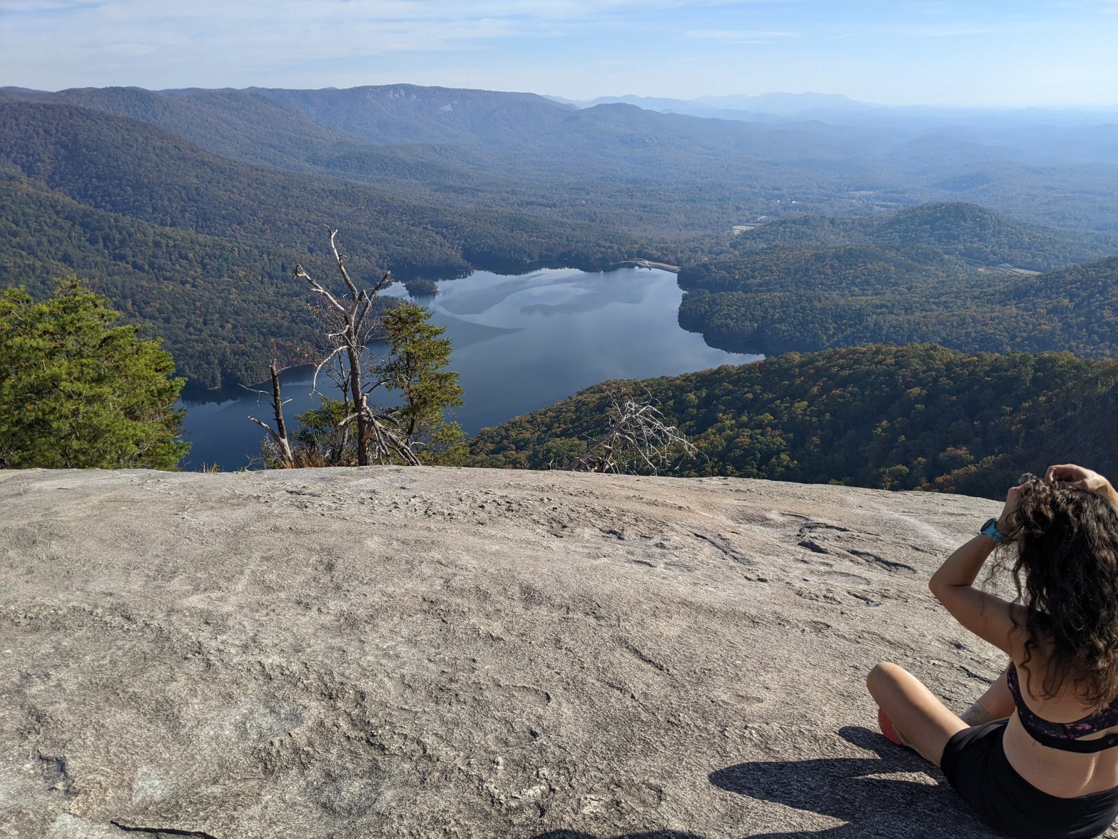
Eventually we emerged on the road. I found some back roads up on the ridge to keep us off the main road on the way to the Visitor’s Center where I braided my hair while taking in the view.


But alas, all good things must come to an end and it was time to keep hiking. After a mile of road walking without a shoulder on a relatively busy two-lane mountain road, we arrived at the trailhead for the Caesars Head Spur of the Foothills Trail. It began ridiculously wide.

The wide trail didn’t last too long, but in it’s place was a nice single track trail without overhanging plants. I really don’t like brushing past the flora on a trail so I appreciated this nice dirt trail and took a photo. There were even some stairs in the steep sections.

The trail stayed nice (and popular- it was a beautiful Sunday afternoon) until the Raven Cliff Falls Overlook.

After that there was a warning sign that we, of course, read and disregarded.

Erik and I spent a few years hiking in the northeast United States- or perhaps to be more correct, climbing and crawling up steep hillsides that often required hand holds on rocks or roots or whatever we could find. So we fully expected this trail might be that difficult. We were glad to find the grade wasn’t too difficulty and we only had to use our hands once on the way down to Matthews Creek, in other words, we’ve been on many more difficult trails.
Within half an hour we were down on the valley floor, just half a mile from where we’d been a few hours earlier. We took the hard route for a better workout and view. The trail was easier down here until we crossed on a dilapidated bridge to the far side of the creek. From here the trail got much steeper and eventually, near the end, there were a few ladders installed. Except for the ladders I didn’t need to use my hands.


At the top of the trail we crossed over the famed suspension bridge. Here the river was just a few feet below us before it plunged over the edge. Too bad we couldn’t get a very good close-up of the falls.


Soon after the Raven Cliff Falls, we took off on the Caesars Head Spur of the Foothills Trail and left the state park. It was nearing 4 pm as we hiked along the trail which was wide and more like a rough road. The Foothills Trail largely follows the ridge, hence there aren’t many water opportunities. Looking at the map, once we hiked up to Gum Gap there wouldn’t be any water for a long ways, so even though it was just pushing 4 pm, we camped near a large spring that feeds Matthews Creek just below Gum Gap.
After setting up camp in true dispersed fashion, we washed up in the ice-cold creek. My feet screamed at me in pain! Then we cooked our dinner of angel hair pasta with taco mix that was less than ideal because I’d messed up and failed to pack the olive oil. Erik made sure to note the meal would’ve been much better with the oil and pretended he was starving.
It got dark early and we killed time in the tent listening to podcasts, trying not to fall asleep until 9 pm when I declared it was finally late enough.
Day Three: 10/24/22

The night got exceptionally cold- Erik’s watch said 32 degrees- way colder than the 45 degrees we were expecting. We could only assume down in this high valley near the spring it was much colder than everywhere else. Indeed, as we began hiking, we got warm quickly and it wasn’t long before I was shirtless again.
The trail continued on logging roads, often straddling the Carolina border, past Gum Gap and Slicking Gap. On the way to Slicking Gap, I got frustrated at the footing on the downhill sections because I couldn’t see the small rocks under the leaves. I felt like we were making dismal progress and we stopped for a break at the only view point along the way, on Dolves Mountain. Had we had our phones on, perhaps they would have been persistently going off “Welcome to North Carolina” and a few seconds later, “Welcome to South Carolina.” At Grunting Spring Gap, the trail veered off the roads to single track, climbing steeply up and down Little Table Rock and then continuing on, sometimes quite steeply, towards Bigspring Mountain. I really wish they’d put in a couple switchbacks on the very steep dirt sections.


After a couple climbs and descents, the trail leveled out although I was quite frustrated that it was somewhat overgrown with a very prickly bush. Despite trying to avoid the bush, at one point my thumb got really stuck on one of the thorns. Hence the “blood” shed on my way to Sassafras. Erik and I began using our poles to try to bash down some of the plants growing over the trail after this.

On the way to Sassafras Gap the single track trail ended and we resumed the dirt road all the way to Sassafras Mountain, South Carolina’s high point. It was steep down and up and I would’ve been quite scared in any kind of vehicle!

Finally the trail ended at the Sassafras Parking lot (pit toilets, no water) and from there we took the paved path to the viewing area.

We ate our first tortilla lunch before heading up onto the viewing platform which is technically half in North Carolina.


After we had our fill of sun and views and still having some miles to cover, we returned to the forest and the Foothills Trail. Here again, the trail was in impeccable condition and I had to take another photo.

We detoured a few steps to the Cantrell Campsite which was quite industrious with at least 3 rooms, each with multiple benches and chairs constructed of rocks and trees. I should’ve taken a photo but suffice it to say, it was the most built-up backcountry site I’ve ever seen. The only downside is a poor water source. I’m unsure if this part of the country was particularly dry this year or if this is usual, but the streams were barely flowing. I suspect this is an ongoing issue as there are small wells (a short length of black plastic pipe set in the stream bed to allow clear water to percolate to the top). These had lids and when Erik poked under the one nearest the Cantrell Campsite he said, “I”m not that desperate for water.”
As we continued on, mostly contouring, and finally filling our water bottles at Emory Creek which looked to be the most reliable water source from our map. It was a small stream that even I could’ve hopped across but it was deep enough to get water. We filled all our bottles knowing this would likely be our last good water source until we got back to our car the next day. This was the only flowing water we found all day. Eventually the trail got rougher (narrower and rockier) as we began side-sloping as we made our way along Pinnacle Mountain under Drawbar Cliffs. Then there was a creek/water crossing with another rope to hold onto. The water here was trickling along and not a great water source. After this we hiked a brief ways and arrived at the Lighthouse Campsite which wasn’t on our Gaia gps map. I also hadn’t bought the Foothills Trail maps which I’m sure included this campsite. Anyway, it was only 4 pm but we were nearing Table Rock State Park where we weren’t supposed to camp and this was a good place so we decided to stay.


As I poked around the campsite, I found a plant with a very pink stem that reminded me of one we had seen in Cinque Terre, Italy in 2017. South Carolina on the left and Italy on the right below.


After setting up our tent, Erik cooked dinner and we ate it on a large rock that, combined with the hillside slope, made us feel like we were up in the trees. After dinner we made a fire. This may have been our first fire on a backpacking trip ever with just the two of us. The evening temperature felt quite temperate.


Day Four: 10/25/22

It never cooled off overnight and Erik’s watch (not on his wrist) read 57 degrees in the morning. Hence, it was easy to get up and get going without being cold. Since we had some miles to make and then had to drive to Georgia, I proposed we hike a bit before breakfast.
At the first point we came to where there’s an intersection with a dirt road there was a guy camped. He was taking pictures of the sunrise which was amazing through the maple trees. Soon we came to the rocky outcropping that was directly above our campsite (we did a big switchback to get there) that afforded a good view and Erik said we should eat breakfast there so we did.


We kept hiking after breakfast and in not too long arrived at our first trail intersection of the day. The Foothills Trail descends here but we elected to hike up to Pinnacle Mountain. The trail was fairly steep. I had initially planned to have breakfast here but Erik had persuaded me not to when we hit that good view spot earlier. Pinnacle Mountain ended up being a forested summit so it was good we had stopped earlier. Instead we brushed our teeth there before beginning our ridge walk to Table Rock viewpoint.
Mostly the trail was in good condition along the ridge but it got wider and more trodden after the intersection with the Table Rock Trail. As we began climbing, just before the Governor’s Rock, the trail got much steeper and rockier with a few slab sections. The weather was good and this wasn’t a problem for us. We sat for a few minutes at the Governor’s Rock before continuing on. Given that Table Rock is a reservoir that serves Greenville, SC, there are signs up everywhere at the drainage boundary not to trespass. We had saw these signs all the previous day as we skirted the drainage. As we gained the summit of Table Rock, the marker was clearly not on the summit so as to keep people away from the Table Rock drainage.

Just pass the Table Rock summit there was an overlook to the east where we stopped. Then we continued to the overlook of Table Rock, mostly on slab rock. It was well worth the walk and I sat and braided my hair while taking in the view.


Then we retraced our steps to the Table Rock Trail before we proceeded down to the Nature Center where we had parked our car at Table Rock State Park. The trail definitely dropped, often with big stone steps in place. By the time we arrived at the Nature Center we were out of water. We replenished and I went swimming to clean up before our next adventure.

Georgia State High Point via the Appalachian Trail
Next up we drove over to Georgia to begin that state’s high point adventure. This would involve hiking out-and-back, first on the Appalachian Trail and then on the Brasstown Bald Trail. I was glad Erik drove so I could enjoy the scenery which was through the “mountains,” again with amazing fall color. We stopped in the small town of Clayton, Georgia for some late lunch and it was interesting to look at all the surrounding hills.
10/25/22

We began hiking the Appalachian Trail from Unicoi Gap with the goal of camping at the Blue Mountain Shelter since the forecast called for rain. I was stoked this might mean some company and that we might meet some Southbounders! I had some reservations though about staying in a shelter after reading Adrienne Hall’s book A Journey North: One Woman’s Story of Hiking the Appalachian Trail where she noted mice problems in the ubiquitous shelters. I don’t like mice- probably because my mom doesn’t like mice:)
It was after 4 pm when we started from Unicoi Gap but we only had a couple miles to go and a 1,000 foot climb so we had plenty of time before sunset. The wind was howling at Unicoi but once we were climbing in the trees I was back stripped down to my sports bra. After the dry conditions in South Carolina we were carrying lots of water- enough to get us to mid-day the next day. We didn’t have much food being out for just two nights so we needed something to weigh down our packs.
I’d hiked a bit on the AT (Appalachian Trail) in New Hampshire and after reading Bill Bryson’s A Walk in the Woods was prepared for giant rocky steps and using my hands frequently but the trail wasn’t nearly that bad. I mean, it wasn’t exactly like walking down my paved city block, but I never had to use my hands.
There were two other groups when we arrived at the Blue Mountain Shelter, both section hikers. They were surprised to find me so scantily clad but I explained I’m Minnesotan. They were from southern Mississippi. One of the groups departed down to their exit at Unicoi Gap, but not before showing us a photo of a black bear they’d just seen. The wind howled as we cooked our dinner and it made us cold despite relatively mild temps.
Two more groups arrived over the course of the evening and I was stoked that the last group were Southbounders!!!
The shelter looked well maintained to which I was relieved until one of the other shelter guests said someone had reported mice a week earlier and that she had swept out a mouse nest upon their arrival. I was less than enthused but fell asleep easily enough only to waken to what sounded like scurrying little creatures that kept me up most of the rest of the night.

Tent please. Thank you.
10/26/22

We all woke up around the same time in the shelter but the Southbounders left first. Erik and I began hiking “southbound” although it was really north. It was very foggy and I hoped the clouds would lift by the time we summited Brasstown Bald, Georgia’s high point, some 7.5 miles away via trail.
The clouds certainly weren’t in a hurry to lift despite an aggressive wind. We hiked on. There were more rocks under leaves and few “cruising” sections where I could walk fast. Maybe someday I’ll get fast on the rocks but most likely not and perhaps I should just give up. At Red Clay Gap we noted a small camping area that was sheltered from the wind. Shortly thereafter (and getting passed by a “flipflopper” who looked to be at least into his late 60s) we diverged from the AT on the Jack’s Knob Trail. This trail was up and down before a final descent to highway 180.
After crossing the small and winding highway 180, we began on the Brasstown Bald Trail which approximately parallels the road to Brasstown Bald. Technically the Bald is a national monument and there is likely a fee station on the road. The trail gains 2,000 feet over 3 miles and so again I expected some ridiculously steep sections but instead we were greeted by a nice hike through the rhododendrons.


We stopped for first lunch along the way and within an hour we arrived at the massive parking lot which sits 500 feet below the Brasstown Bald summit. From here you can either hike a steep paved path to the top or jump on a small shuttle bus.

Unfortunately the summit was in the clouds and the wind was still blasting so it was cold. We warmed up in some heated bathrooms and put on our rain jackets before resuming.
I’m guessing the summit would be tree covered if it wasn’t for a visitors center and some decks. There’s also an observation tower (which the dated movie we watched in the Mountain Top Theater said was an active fire tower). The observation tower was closed but seeing as there wasn’t anything to look at besides clouds we weren’t too disappointed. Also of note, because this mountain is relatively high at over 4,874 feet, it’s covered in snow most of the winter and the vegetation mimics that of northern Minnesota.


After the movie the clouds broke a couple times. We debated staying longer seeing as the forecast called for clearing skies throughout the day but eventually decided it was time to go. As we descended it got more and more clear and by the time we were back to the giant parking lot the summit was completely out of the clouds. Here we filled up our water bottles to get us through the next 20 hours until we got back to the car. This left time to debate heading back up to the summit but Erik wasn’t too interested and so we hiked down, thinking about the great view we’d missed by minutes.

By the time we were back across highway 180 and ascending I felt a little less bad but was still salty eating second lunch in the trees instead of on top of a mountain. I kinda set the goal of that campsite we had passed early in the morning at Red Clay Gap and when we got there, even though it wasn’t quite yet 5 pm, we decided to stay for the night.

We set up the tent and then Erik wanted to scout for water on the blue blazed trail. I recalled from Adrienne Hall’s book that as if the AT wasn’t difficult enough, there was a search for water every night. I’m glad we headed down that water trail because it was ridiculously steep and I eventually, after holding onto roots and trees and almost falling several times, gave up. Erik persisted, 0.2 miles and 250 vertical feet below the campsite to find a meager stream.
When Erik arrived back to camp we cooked and ate dinner, the sunlight gradually fading. Then we crawled in the tent and tried not to fall asleep until 9 pm. It felt quite cold.
10/27/22

We only had 4 miles to hike out but then a solid five hour drive to Charleston so we got moving once it got light. It had slightly warmed up overnight and the wind had died down. There were again the cruising sections and the rocky sections and we encountered a group of Southbounders, at least one of whom had a giant pack. As we got near the Blue Mountain Shelter we saw a black bear about 50 feet down slope of the trail. It was quite photogenic and we took a few pictures before continuing on.

Erik stopped to use the outhouse at the shelter while I took some photos of the clouds down in the valley that looked like water. Then we continued on down to Unicoi, the route seeming longer than two days previous.


Charleston, South Carolina
I love old houses which is why I wanted to go to Charleston but I’m not one for fashion, wearing make-up, or going to restaurants. Hence, arriving at the lobby of our fancy hotel and then immediately walking down King Street totally unaware that this was the main shopping avenue, made me feel quite out of place compared to the woods. I even wrote a poem about it:

Over the four days we had in Charleston (two partial), in addition to attending my conference, we walked and ran over almost the entire city (including the less glamorous parts), saw hundreds of college kids in Halloween costumes, and made it to Folly Beach.


I don’t know that I’ll go back to Charleston although I did like looking at all the old houses. But I was enamored by the hills of northern Georgia and totally want to go back someday- and maybe seek revenge on the view from Brasstown Bald. Although we still have the Tennessee and North Carolina high points which also have roads to the top and observation decks and are much higher. I’d also highly recommend our South Carolina loop, especially during peak fall colors. It was a real treat to experience them twice in one season and perhaps I’ll try to chase them more in years to come.

3 thoughts on “Backpacking the South Carolina and Georgia High Points”